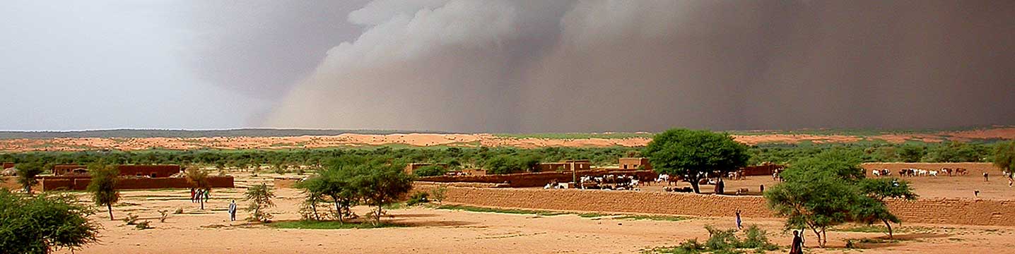
Welcome to AMMA-2050 In recent decades, West Africa has experienced some of the most extreme rainfall variability anywhere in the world. This climatic variability is directly affecting the livelihoods of its growing population. In this region rainfall is notoriously variable and contributed to an extensive and long-lived drought triggering regional scale famine in the 1970s and 1980s. In more recent years, a partial recovery of seasonal rainfall totals in the Sahel has been accompanied by devastating flooding events. Despite a good understanding of the physical causes of historical climate variability, there is no clear agreement on how changes in greenhouse gases, land cover and aerosols will impact future rainfall. When looking at the impact on societies, there is little information on how high impact weather events may change in the future. This uncertainty, coupled with weak capability to plan investments on timescales of decades, results in the limited climate change knowledge being used as a guide to development decision-making. This project will build on the largest multidisciplinary research effort ever undertaken in the area of African climate and environment, the African Monsoon Multidisciplinary Analysis (AMMA), to address the challenges of understanding how the monsoon will change in future decades, and how this information can be most effectively used to support climate-compatible development in the region. Objectives This collaborative project between scientists and policy makers in West Africa and Europe aims to increase understanding of the regional climate and how it will change, and also apply that knowledge to practical development questions. We will focus on weather events that significantly impact on livelihoods (e.g. flood-producing storms, crop-damaging dry spells), and combine traditional computer models of climate change with observations and cutting edge regional models which realistically depict individual storms. Applying expert judgement to these outputs, we will identify impacts and adaptation options in water resources and agriculture, including targeted studies on urban flooding and crop breeding. we will provide expert judgement on future projections of High Impact Weather and climate which is tailored specifically to the needs of decision-makers. we will create tools and methodologies for using these projections for planning within the agricultural and hydrological sectors. we will demonstrate the potential for effective application of reliable 5-40 year climate projections and associated uncertainties in regional to local scale decision-making. We will translate regional climate projections, accounting for physical uncertainty and socio-economic context, into regional projections for water resources and agriculture, including pilot studies on urban flooding and resilient agriculture. Decision makers will be integrated from the outset, using an ‘assess-risk-of-policy’ framing whereby decision makers will have an essential role in framing uncertainty descriptions – assisting users to take ownership of the research and simultaneously building capacity. A key objective underpinning all of our work is the development of skilled researchers in West Africa, alongside increased uptake of climate information in decision-making. Region of work The geographical focus of AMMA-2050 is West Africa This region stretches from the semi-arid Sahel, on the southern fringes of the Sahara desert, down to the moist tropical conditions bordering the Gulf of Guinea. The climate of the region is dominated by the West African monsoon, when winds carry moist air from the Atlantic Ocean towards the interior of the continent during the summer months. The strong decreases in annual rainfall as one travels north, produce dramatic changes in vegetation, from dense tropical forests in parts of Cote d’Ivoire, Liberia and Ghana, through lush savannas, to barren landscapes in the far north, which come alive with vegetation when the rains arrive. The contrasting climate across the region dictates patterns of agriculture. Subsistence farming of crops such as millet and sorghum predominate in the Sahel, whilst areas with higher rainfall are increasingly being turned over to production of export crops. Within AMMA-205 we have detailed Pilot work, focusing on: Senegalese agriculture city of Ouagadougou, Burkina Faso The climate of West Africa is subject to some of the most variable rainfall patterns observed anywhere in the world. During the 1970s and 1980s, the region suffered severe droughts, whilst more recently major flood events have struck a number of the region's rapidly expanding cities. The consequences of these climatic extremes for the population have been particularly pronounced due to widespread and severe poverty. Global climate change, coming on top of such a variable and unpredictable regional climate, poses a major threat to the populations and economies of West Africa. Although the pathway from climate change to human suffering in West Africa is very short, there are some key bottlenecks to using climate projections to mitigate against risks to the population. Critical gaps exist in knowledge of how West African climate will change over the course of the 21st century, and the uncertainties make it almost impossible for agencies to deliver well-informed plans for the coming decades in critical areas such as food security, urban development and water. Even with the best climate information, it remains a significant challenge to integrate the scientific knowledge into planning and management structures. Getting past these bottlenecks, both gaps in climate knowledge and methods to incorporate inherent uncertainty in planning, is the aim of the AMMA-2050 project. Approach The approach of AMMA-2050 The climate of West Africa is subject to some of the most variable rainfall patterns observed anywhere in the world. During the 1970s and 1980s, the region suffered severe droughts, whilst more recently major flood events have struck a number of the region's rapidly expanding cities. The consequences of these climatic extremes for the population have been particularly pronounced due to widespread and severe poverty. Global climate change, coming on top of such a variable and unpredictable regional climate, poses a major threat to the populations and economies of West Africa. Although the pathway from climate change to human suffering in West Africa is very short, there are some key bottlenecks to using climate projections to mitigate against risks to the population. Critical gaps exist in knowledge of how West African climate will change over the course of the 21st century, and the uncertainties make it almost impossible for agencies to deliver well-informed plans for the coming decades in critical areas such as food security, urban development and water. Even with the best climate information, it remains a significant challenge to integrate the scientific knowledge into planning and management structures. Getting past these bottlenecks, both gaps in climate knowledge and methods to incorporate inherent uncertainty in planning, is the aim of the AMMA-2050 project. Expected impact Our desired impact West Africa has a history of prolonged and severe droughts, most notably in its semi-arid Sahelian region. With respect to future climate, a lack of understanding and consensus is a limiting factor for decision-makers in West Africa. Providing measures for future climate changes and of the associated uncertainties in: seasonal rainfall, High Impact Weather and their impacts, allows risk-based information to feed into pathways approaches of decision making. By involving scientists, decision makers and other stakeholders, we aim to promote the co-production and ownership of decisions sensitive to climate variability and change. Our two pilot studies, focus on flooding in the City of Ouagadougou and on Climate-Smart agriculture intensification and adaptation in Senegal, provide in-depth examples of the benefits that can arise from access to excellent and relevant research for decision makers. Building on this work we have two additional studies looking at the sanitation flow in the city of Ouagadougou, and the impact of climate change on coastal fisheries in Senegal. Through these partnerships we aim to communicate science in an appropriate way to the right decision/policy makers & showing how it fits their policy needs Our Impact Case Studies demonstrate how the collaborations within AMMA2050 have strengthened scientists’ capacities to develop decision-relevant climate information and how that has increased the capacities of users/decision making bodies/institutions to appropriately integrate climate information within medium-term decision-making. More and more flooding in Ouagadougou and The production of the Climate Metric Atlas. Principal Investigator Dr. Christopher Taylor Meteorologist PI for African Monsoon Multi-disciplinary Analysis-2050 Read more